Showing posts with label ice skating. Show all posts

Tuesday, December 27, 2011

December 2011-Exceptional Season of Ice Skating in the Sierras

The month of December resulted in no significant precipitation to cover the ice that had been formed. Conditions remained cold with polar air streaming around the stationary ridge that was blocking the storm systems. The high pressure was promoting subsidence inversions that was capping the cold air in the valleys. Some low lying areas were much colder than higher elevations. Temperatures dropped into the single digits and even subzero temperatures the week before the winter solstice. Without any snow, ice skating became prevalent in the Lake Tahoe area and all along the Eastern Sierras. With it this good, it even made the main stream news.

Bridgeport Reservoir December 10th

Virginia Lake December 10th (old but clean sections-good for the Alpenglow)

Tioga Lake December 11th (next 4 pics) - old thick but glassy between crack lines


Prosser Reservoir
Temperatures in the basin around Truckee were getting into the single digits and this provided solid 6-8" ice on Prosser Reservoir. Most of the lake was frozen with the west arm having the most consistent smooth ice and easy access. Several other lakes and ponds in the Tahoe area had excellent ice skating conditions.


More Pictures December 23rd:
https://picasaweb.google.com/111461517128275850244/20111223IceSkateProsserReservoir?authuser=0&feat=directlink


Conditions at Tenaya Lake
This a beautiful lake in Yosemite accessible by Highway 120.  This is quintessential treat for anyone that loves skating on natural ice.  Tenaya was marginal in early December, but consistent drops into the teens thickened the ice.  This inspired skaters from all over to come enjoy it.


..Gotta do another road trip
Some videos on YouTube inspired me to head back up, since being able to drive to Tenaya and have good ice this time of year are both rare.   It looked like the night/morning of 12/27-28 was going to be the last of the cold period AND it was holiday season.  Gotta try.....
We got to Tenaya and skated at sunrise (of course the ~East/West orientation keeps the lake in shade for quite a while this time of year-which is good).   The ice was a foot thick with the thinnest spots in isolated areas around 4-5" thick and only a few melt spots near the outlet and a spot in the middle that was sheeted but thin.  The ~north side of the lake had the ice buckled up onto the shore form expansion; the expansion actually having moved boulders.  The south side which appeared to remain in the shade, was clear black ice.  Although cracked, there were stretches of very glassy smooth ice that provided incredible glides with a view of the lake bottom.  Being able to see through ice while skating is a treat.  It feels as though I'm simultaneously observing a transcendence of dimensions and physical phases while in motion. 
We arrived and skated in solitude for a couple hours.  Soon skates and travellers showed up.  By the time we left around 1:30pm, there were well over a hundred people enjoying the ice.  Temperatures in warm spots were close to 60°F and people began sunbathing.  The ice surface began to form a skim layer that was getting close to the high spots by the time we left.  The south side in the shade remained good quality with no apparent melt.  If no snow falls over the next couple weeks, the melted skim layer could form a natural Zamboni effect.  With the slab of ice that is already there, clear nights with lows in the low 20s or teens should keep the ice in good shape, with the skim layer even improving the surface. 

Temperature trend shows warming on the afternoon of the 28th which formed skim layer:

Tenaya Lake Morning of December 28th


It was so good I went back twice......

Worth the Choreography.....

It is mid-January and still no snow.  Temps have been cold enough that morning skates are probably still good although ice is getting old and blemished with surface aberations even with some skim layers forming.

Link to more pictures: https://picasaweb.google.com/111461517128275850244/20111228TenayaLakeIceSkate?authuser=0&feat=directlink


Below is a link to a video someone posted online in mid-December.  Made me want to head back up for one more skate.


Synoptic Weather Pattern in Early December Setting up a persistent pattern


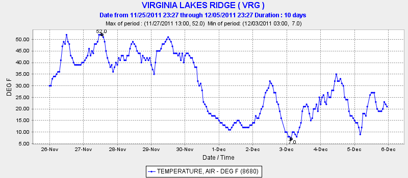
Recent strong NE winds may have blown the small amount of snow off any previous ice if the snow did not fall wet or cause snow ice. The following plot is from the CDEC Water resources site: http://cdec.water.ca.gov/cgi-progs/queryF?TNY



Sources of Temperature Data for Estimating Ice Formation

Other locations for California can be found here: http://cdec.water.ca.gov/cgi-progs/mapper
These data go back some time so that that trends over the entire fall can be looked at.
Another good source of surface data to see temperature trends is the Mesowest site which provides data and plots of temperature for the past 7 days for various regions:
Temperatures provided by surface stations are representative and can actually vary significantly from microscale conditions at the water body(s) of interest. Overall trends with regional weather stations should be considered along with observations. It is obviously easiest to watch the ice form and make physical measurements of thickness along with observing temperatures; however, this is often not practical. With remote sensing data available on the internet, the likelihood of ice formation can determined adequately enough to pursue further investigation.

Early December 2011 Temperature Forecasts

Forecast for the week is single digits and teens for lows in the Eastern Sierra cold air basins. Some inversions indicated at upper levels moderating temperatures, but generally colder higher up. Daytime highs in the 30s and 40s. A week worth of single digit lows and only 8 hours of daylight for ramping

Monday, December 26, 2011

Ice Skating on Natural Ice in California


With changes in temperature and weather patterns bring changes in recreational opportunities. Every late fall on the approaching winter solstice there is the potential for good natural ice for ice skating.  The winter solstice with low sun angles and long nights often brings cold temperatures to high elevations. This can be augmented with favorable weather conditions. When snow does not prevail for snow sports, ice can be great if a persistent polar jet sets up with only early fall snows to chill down the water.


Skating Bridgeport Lake


Ice Safety
 Testing the ice is curucial for safety.  A drill is usful for verifying thickness.  In good water ice, cracks can give an estimate of thickness from the thickness of the shearplane.  Also, small bubbles can indicate depth.  Over 3" of good water ice is adequate for supporting a skater; 5-6" provides good margins.  A portable electric drill with a 1/2-3/4" diam. 6" long bit works well for determining thickness (keep battery from cold soaking prior to use). 
The Kiwis have been making good use of ice on the South Island of New Zealand have an excellent site with good eneral information (I'm going to have to go skate there sometime; the east side is much like the Eastern Sierra).  http://iceblock.org.nz/safety/
Here are additional sites with useful information on ice formation and safety:
http://www.blueiceonline.com/howsite/lakeice_about.html
http://lakeice.squarespace.com/thickness/
http://www2.gi.alaska.edu/alison/ALISON_SCIENCE_BConcepts.html


It is important to recognize ice variabiilty inherent with water bodies.based upon subsuface flow, artesians, springs, inlets/outlets. Surveying ice from aircraft can help identifying good ice areas.


Weather and Ice
 The weather is of course crucial for not just forming thick enough ice but also the quality.  Late November 2011 has provided a string of dry cold days due to a stationary high pressure and a low to the south with the polar jet providing the chilldown.  The condition is somewhat characteristic of a Rex Block which is the reverse "S" pattern of the high pressure which prevents eastward migration of the high pressure from the the complimentary cyclonic and anti-cyclonic flow around the low and high.  A key is a persistent high pressure over the west coast blocking storm systems with the anti-cyclonic cold northerly flow around the high providing the low temperatures needed.  These persistent cold dry condition can be favorable for good ice formation.  Monitoring the weather conditions can help identify periods favorable to ice formation.
Weather is particularily important in the Sierras for determining good safe ice due to the relatively mild conditions that can prevail in fall.  It is the trends and duration of cold that provide good sheeting.  Although ice can thicken into January and February at higher elevations where freezing condiotns are more persistent, the best quality ice often occurs early season before much snow has fallen and ruined surface conditions.  The short days of late fall provide the advantage of duration or cold nights and low sun angles to provide net freezing. 
The following graph illustrates typical trends ice sheet formation thickness versus time for various temperatures:


December 2011-Exceptional Season of Ice Skating in the Sierras
The month of December resulted in no significant precipitation to cover the ice that had been formed.  Conditions remained cold with polar air streaming around the stationary ridge that was blocking the storm systems.   The high pressure was promoting subsidence inversions that was capping the cold air in the valleys.  Some low lying areas were much colder than higher elevations.  Temperatures dropped into the single digits and even subzero temperatures the week before the winter solstice.   Without any snow, ice skating became prevalent in the Lake Tahoe area and all along the Eastern Sierras.  With it this good, it even made the main stream news.

Bridgeport Reservoir

 Virginia Lake

 Tioga Lake


Ice Skating on Natural Ice in California: Development of an Index for Remotely Estimating Probable Ice Formation

Availability of real-time weather data has revolutionized the ability to monitor remote locations for conditions suitable for ice formation. Since ice formation requires sustained cold temperatures one can surmise that if one were to quantify the amount of freezing versus thawing, one could come up with a reasonable estimate of forecasting ice. There are other variables that go into good quality skating ice, but paramount is temperature trends.  This is particurily helpful if one does not reside near the water bodies in question.

The short days and long nights in late fall provide a skewing of cooling/freezing hours. When temperatures fall below freezing at sunset and stay freezing after sunrise for several days during late fall-winter solstice times, ice formation becomes more favorable. Since temperature can spike during the day, temperatures typically need to fall well below freezing to insure adequate cooling to overcome heat flux form absorbed solar heat and latent heat exchange.  Otherwise, thawing occurs.  Optimum conditions often occur on new water ice that sheets clean rapidly in very cold calm conditions. Rapid cooling can produce ice with fewer air bubbles making the ice clear and transparent. Once ice has formed, latent heat of fusion works to the advantage of maintaining state through short warming periods allowing water ice to form in subsequent cold snaps; however, it is the new ice that is often the best and also the thinnest.  Ice for ice skating is often good early season before snow has had a chance to cover the ice and ruin the ice. Ice that has under gone excessive freeze-thaw, strong winds or accumulated debris can ruin the quality also.    Old ice tends to crack and form ridges which ruins quality. Early season/late fall ice is often best; often this ice is on the thin side which requires careful monitoring of conditions during formation.


Ice Formation Index

For lack of a better term, I am using this term to describe the integrated temperature conditions over time that favor ice formation for ice skating. The index utilizes the a concept of integrated temperature accumulation above or below a reference value to indicate an accumulative effect.   Although one could use an average, that can be misleading, since spiked low minimum temperatures can skew the average. In this case, temperature is often logged in hourly increments by various weather reporting stations such as the CDEC and Mesowest. These data can the summed (integrated) for periods above and below freezing [#hours X temperature for <=32F and >32F] and then the ratio [ratio of degree-hours below freezing to that above freezing = FDH/HDH]  or the net freezing [FDH-HDH] provides a quantitative way to compare observations with ice formation.  The Index Ratio should be >1 or thawing is likely, degrading the ice and making the ice structure unsafe.  
Ratios of  >5 indicated skatable or thick ice this season.  The Net Freezing Degree Hours were 1400-2000 for 7 days for observed skatable lakes.  Below is an example of processing a weeks worth of data from near Bridgeport, California.  Data was copied into a spreadsheet and the values computed:


This resulted in 3-4" of ice on Bridgeport Reservoir.  Observation of the temperature plot shows the long duration of cold temperatures with only short spikes above 32°F.  A week of single digit lows around early December (after water has chilled during November) is an indication ice is potentially thick enough to skate on.


The following chart is an estimation gleaned from one the websites below and is a representation of ice formation trends.  It shows an inital rapid phase and then a slowing of thickening. The graph is somewhat idealized since actual temperatures and diurnal/nocturnal heat flux could add significant variabilty from mean daily temperatures.    Nevertheless, five days of net freezing shows sheet ice thick enough to skate.   This is consistent with several years of observations in the Sierras. 


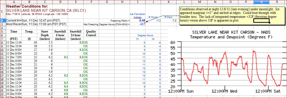
An example of Index where the ratio was <1 is for Silver Lake near Kit Carson Pass.  The ratio 0.48 and there was a negative Net Freezing Degree Hours.   Observations on the evening of 12/8 indicated that ice was marginal <2" and melted at the edges.   The water had been chilled by early snowfall but was being warmed by warm air subsidence inversions on the west slopes of Sierras during preceeding days limiting nocturnal cooling.


Prosser Reservoir Near Truckee
The following temperature plot from CDEC data (Martis Creek Res.) is near Prosser Reservoir and shows the temperature dipping in early December 2011.  The lake was skatable by 12/10 with marginal thicknesses (reported).   There werew 5 nights of teens and single digits. Another 10 days resulted in thicknesses of 6-8" around the solstice.  During that time there was light snowfall on one occasion with minor effect on the ice quality. 


When there is any question of thickness, the ice should be measured in several representative locations. Ideally, ice thickness can be measure with an auger or spike. It should at least estimated for a given location. Cracks or bubbles in clear ice can give and indication of thickness by simple visual parallax. Nevertheless, water does not freeze if the temperature is not cold enough. So this approach is a way to 'quantify the cold'. The data becomes a tool in predicting when good ice skating conditions can be had. There are many other variables which influence ice formation on a water body/feature, such as, size, depth, flows/currents, springs, topography and weather are important for specific locations. All of this should be taken into account. Air temperature is one of the most useful parameters readily available as an indication of the likelihood of ice formation. Additional data such as solar radiation, wind and snow-pack are also useful indicators for understanding the melt freeze cycle and probable characteristics of any ice present, particularly the presence of water ice or snow ice.

Occasionally, when ice freezes before snow falls, the ice can still be skatable. If the conditions remain cold and the snow does not bond with the ice, up to 2 inches can still allow for adequate glide over the ice. Since the ice is obscured, it is even more imperative the thickness should be verified.
Often early fall snow falls can form snow ice which will result in a lot of air bubbles in the ice which can make the ice weaker requiring extra thickness to account for that weakness. The most significant quality issue with snow ice is that is often creates a rougher surface even if the surface remelts. Ironically, early fall snows followed by a slight warming trend to melt any snow ice will chill the water and make it more conducive to freezing during a cold snap in late fall.


Sources of Temperature Data for Estimating Ice Formation

Other locations for California can be found here: http://cdec.water.ca.gov/cgi-progs/mapper
These data go back some time so that that trends over the entire fall can be looked at.
Another good source of surface data to see temperature trends is the Mesowest site which provides data and plots of temperature for the past 7 days for various regions:
Temperatures provided by surface stations are representative and can actually vary significantly from microscale conditions at the water body(s) of interest. Overall trends with regional weather stations should be considered along with observations. It is obviously easiest to watch the ice form and make physical measurements of thickness along with observing temperatures; however, this is often not practical. With remote sensing data available on the internet, the likelyhood of ice formation can deterimined adequately enough to pursue further investigation.
Early December 2011 Temperature Forecasts

Forecast for the week is single digits and teens for lows in the Eastern Sierra cold air basins. Some inversions indicated at upper levels moderating temperatures, but generally colder higher up. Daytime highs in the 30s and 40s. A week worth of single digit lows and only 8 hours of daylight for ramping with maxes in the 40s usually means a net gain in thickness. The slight warming in the day can help glaze the ice, a natural zamboni effect.


Links: